En
Log in
All resources
Create a design
Tools
7,118 Free Images of Engraved Maps
baroque
engravings of topographia braunschweig lüneburg
copper engraving print
british library
joan blaeu
map of amsterdam by julius milheuser after daniël stalpaert, 1662
julius milheuser
maps from the earth and its inhabitants, vol. iv
national library of poland
engravings of castles in lower saxony
jan karel donatus van beecq
hernán cortés
engravings of topographia braunschweig lüneburg
baroque
atlas maior, vol 5 (england) - joan blaeu, 1667 - bl 114.h(star).5
17th-century maps of yorkshire
atlas maior, vol 7 (france i) - joan blaeu, 1667 - bl 114.h(star).7
1667 maps
map of bruges by marcus gheeraerts (i)
drawings in the groeningemuseum
atlas maior, vol 2 (sweden, russia, poland, eastern europe, and greece) - joan blaeu, 1667 - bl 114.h(star).2
17th-century maps of scandinavia
atlas maior, vol 5 (england) - joan blaeu, 1667 - bl 114.h(star).5
17th-century maps of yorkshire
vrbivm praecipvarvm totivs mvndi (1612)
maps of bolsward by braun & hogenberg
vrbivm praecipvarvm totivs mvndi (1612)
maps of dokkum by braun & hogenberg
maps of barbary coast by mercator-hondius
conquest of majorca
engravings of topographia braunschweig lüneburg
baroque
engravings of topographia braunschweig lüneburg
baroque
engravings of topographia braunschweig lüneburg
baroque
engravings of topographia braunschweig lüneburg
baroque
turgot map of paris – derivative files
old maps of île saint-louis
engravings of topographia braunschweig lüneburg
baroque
historical
history
maps of haarlemmerhout
old maps of haarlem
map of amsterdam by julius milheuser after daniël stalpaert, 1662
julius milheuser
map of amsterdam by julius milheuser after daniël stalpaert, 1662
julius milheuser
map of amsterdam by julius milheuser after daniël stalpaert, 1662
julius milheuser
map of amsterdam by julius milheuser after daniël stalpaert, 1662
julius milheuser
eran laor cartographic collection
pierre françois tardieu
maps of portugal by fernando álvares seco
maps
theatri praecipvarvm totivs mvndi vrbivm : liber sextvs (1618)
maps of york by braun & hogenberg
map of amsterdam by julius milheuser after daniël stalpaert, 1662
julius milheuser
atlas ou representation du monde universel t. 2 (1633)
old maps of the republic of genoa
atlas ou representation du monde universel t. 2 (1633)
maps by hendrik hondius the younger
maps from the earth and its inhabitants, vol. viii
buddhist pilgrimage sites in india
engravings of topographia braunschweig lüneburg
baroque
miniature speed atlas (1627) pieter van den keere
county maps of england by john speed
maps of paris by braun & hogenberg
georg braun
1830 maps of the united states
maps by george w. boynton
maps of barbary coast by mercator-hondius
maps by jan janssonius
map of amsterdam by julius milheuser after daniël stalpaert, 1662
julius milheuser
map of amsterdam by julius milheuser after daniël stalpaert, 1662
julius milheuser
maps from the earth and its inhabitants, vol. vi
latin-language maps
theatri praecipvarvm totivs mvndi vrbivm : liber sextvs (1618)
maps of heilbronn by braun & hogenberg
atlas maior, vol 10 (spain and africa) - joan blaeu, 1667 - bl 114.h(star).10
1667 maps
maps of bergen (norway) by braun & hogenberg
1580s engravings
maps of the divisions of the polish-lithuanian commonwealth
karol de perthées
juan de la cruz cano y olmedilla
maps by tomas lopez
juan de la cruz cano y olmedilla
maps by tomas lopez
maps by pieter mortier
indochina
map of bruges by marcus gheeraerts (i)
engravings
eran laor cartographic collection
engravings by frans hogenberg
maps from the earth and its inhabitants, vol. xvii
anton francesco lucini
maps from the earth and its inhabitants, vol. xv
exploration of the arctic
turgot map of paris, norman b. leventhal map center – derivative files
rue de braque on maps
1803 in berlin
1803 maps
moïse-jean-baptiste fouard
corsair wars
19th-century maps of crimea
g. h. swanston
köln-weidenpesch
köln-nippes
engravings by romeyn de hooghe
engravings by jan luyken
festung lichtenau
baroque
st thomas' hospital (southwark)
guy's hospital
maps from the earth and its inhabitants, vol. iv
topographic maps of the united kingdom
maps from the earth and its inhabitants, vol. xii
19th-century maps of senegal
maps from the earth and its inhabitants, vol. iv
topographic maps of ireland
old maps of la gomera
1878 maps of spain
maps from the earth and its inhabitants, vol. xiv
1870s maps of new zealand
1600s maps of the world
copper engravings
atlas van der hagen (volume 2)
atlas van der hagen
maps from the earth and its inhabitants, vol. iv
old maps of the lake district
maps from the earth and its inhabitants, vol. xv
19th-century maps of british columbia
maps from the earth and its inhabitants, vol. xv
19th-century maps of british columbia
engravings of topographia braunschweig lüneburg
baroque
maps by willem and johannes blaeu
1635 maps of africa
engravings of topographia palatinatus rheni
baroque
engravings of topographia braunschweig lüneburg
baroque
engravings of cities
baroque
maps from the earth and its inhabitants, vol. xiii
maps of weather and climate of south africa
maps from the earth and its inhabitants, vol. iv
maps of loch fyne
maps of the western cape
breede river
maps from the earth and its inhabitants, vol. iv
maps of kirkwall
cetus (constellation) in art
uranometria
miniature speed atlas (1627) pieter van den keere
maps of wales by john speed
maps from the earth and its inhabitants, vol. vii
maps of the yellow river
maps from the earth and its inhabitants, vol. iv
mouth of tay
maps from the earth and its inhabitants, vol. xii
maps of icebergs
maps of rivers of senegal
bafing river
old maps of south africa
maps of the great trek
maps from the earth and its inhabitants, vol. viii
demographic maps of thailand
maps from the earth and its inhabitants, vol. xiii
ethnographic maps of africa
flemish prints in the rijksmuseum amsterdam
maps of amersfoort by braun & hogenberg
maps by jodocus hondius
maps by petrus bertius
düsseldorf in the 1800s
old maps of düsseldorf
atlas maior, vol 12 (america) - joan blaeu, 1667 - bl 114.h(star).12
1667 maps
maps from the earth and its inhabitants, vol. vi
charles eugène perron
maps from the earth and its inhabitants, vol. iv
maps of portland, england
maps from the earth and its inhabitants, vol. ix
maps of telegraph lines
maps from the earth and its inhabitants, vol. vii
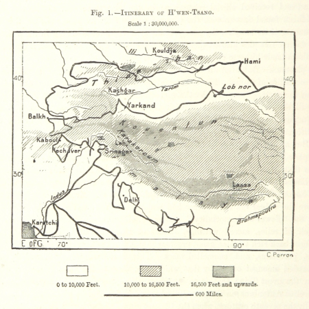
maps of xuanzang's travels
maps from the earth and its inhabitants, vol. xv
maps indicating exploration
maps from the earth and its inhabitants, vol. xi
maps indicating exploration
maps from the earth and its inhabitants, vol. x
19th-century maps of egypt
print room of the university of antwerp
citadel van antwerpen
maps in the british museum
prints by mario cartaro
atlas maior, vol 2 (sweden, russia, poland, eastern europe, and greece) - joan blaeu, 1667 - bl 114.h(star).2
17th-century maps of finland
atlas maior, vol 5 (england) - joan blaeu, 1667 - bl 114.h(star).5
old maps of anglo-saxon england
maps from the earth and its inhabitants, vol. xvii
maps of louisville, kentucky
1101 - 1200 of 7,118
Next page
/ 72